When Coronado Was Actually Two Separate Islands
Permanently altered the geographic coastline of Southern California and created the unified modern peninsula that serves as the Pacific Fleet’s premier aviation installation.
"Why do old maps from the 1800s and early 1900s show two separate islands named "North Island" and "South Island" separated by open Pacific ocean waters?"
Listen to the historical narrative via browser voice narration
Until World War II, a shallow waterway called Spanish Bight separated North Island from South Island (Coronado proper). In 1944-1945, the Navy Seabees filled in Spanish Bight with millions of cubic yards of sand to expand airfield runways, permanently fusing the two into one landmass.
Archival Photographic Evidence
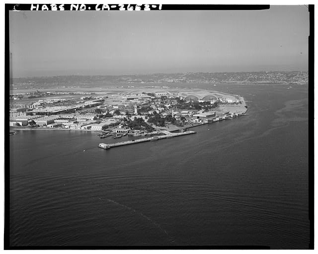
The natural tidal channel known as Spanish Bight, which separated North Island from Coronado until 1944 when the U.S. Navy Bureau of Yards and Docks filled the channel for military aircraft runways.
Complete Archival Investigation
For centuries, the Coronado landform consisted of two distinct geographic islands. To the north lay the rugged, brush-covered sandspit of North Island (originally known as Isla de San Diego), home to jackrabbits, wild quail, and pelican rookeries. To the south lay the residential and resort settlement of South Island (Coronado proper).
Separating these two landmasses was Spanish Bight, a natural tidal channel that connected the Pacific Ocean on the west directly with San Diego Bay on the east. During high tide, ocean water poured through Spanish Bight, and local mariners navigated sailboats and rowboats directly through the passage.
In 1911, aviation pioneer Glenn H. Curtiss established the world’s first military aviation training encampment on North Island specifically because Spanish Bight and Glorietta Bay provided protected bodies of flat water for testing experimental seaplanes. During World War I and the 1920s, a timber trestle bridge carried automobiles across Spanish Bight between Coronado and the Naval Air Station.
With the outbreak of World War II in the Pacific, Naval Air Station North Island became the supreme logistical and aircraft carrier staging depot for the Allied war effort. Massive new long-range patrol bombers and fighter wings required concrete runways far longer than North Island’s existing borders could accommodate. In late 1944, under emergency wartime authorizations, the U.S. Navy executed one of the largest coastal reclamation projects in California history.
The Wartime Dredging Operation
The U.S. Navy Bureau of Yards and Docks deployed heavy hydraulic cutterhead dredges into San Diego Bay. Over 28 million cubic yards of sand and silt were pumped directly into Spanish Bight. Working around the clock under blackout conditions, Navy Seabees and civilian engineers filled the entire waterway, compacting the seabed into high-bearing foundations.
Runway Expansion for the Pacific Carrier Fleet
Over the newly reclaimed land of former Spanish Bight, the Navy poured thousands of feet of high-strength concrete runways capable of handling heavy PB4Y Privateers, PBM Mariners, and carrier-based aircraft. The unified airfield remains in continuous operational use today by Naval Air Station North Island.
Tracing the Ghost Waterway Today
Modern visitors driving along Alameda Boulevard or Fourth Street to the North Island security gates are passing directly over the buried waters of Spanish Bight. Underground utility records, soil boring samples, and civil engineering surveys still clearly delineate the historic sandy channel bed.
Archival & Engineering Specifications
| Former Waterway Name | Spanish Bight (Brazo del Bight) |
| Original Depth | Tidal marsh ranging from 2 ft to 14 ft depth |
| Reclamation Volume | Over 28,000,000 cubic yards of dredged sand |
| Filling Period | 1944-1945 (Emergency World War II expansion) |
| Executing Command | U.S. Navy Bureau of Yards and Docks & Naval Seabees |
| Modern Status | Paved runways, taxiways, and military facilities of NAS North Island |
Archival Quotes & Eyewitness Testimonies
"The bight between North Island and the town was a sportsman’s paradise, alive with teal, curlew, and yellowlegs."
"By closing Spanish Bight, the Navy unified the land and created the most vital air bastion in the Pacific Theater."
Frequently Asked Questions
Questions & AnswersCan you still see where Spanish Bight was? ↓
From high-altitude satellite views or historical aerial survey comparisons, the linear boundary where Spanish Bight once ran is readily identifiable along the boundary line between the city of Coronado and Naval Air Station North Island.
How did people travel between Coronado and North Island before 1944? ↓
Before 1944, visitors and military personnel crossed Spanish Bight via small passenger ferries or a wooden motor trestle bridge constructed during World War I.
Did filling Spanish Bight change bay tidal currents? ↓
Yes. Closing the channel eliminated tidal flushing between the outer ocean and the inner bay at that point, which engineers stabilized by reinforcing harbor seawalls and deepening the main shipping channel.
Primary Archival Sources & Repository Citations
HISTORIC ARCHIVEConnected Timeline Records & Key Historical Figures
Share Chronicle & Academic Citation
Distribute verified Coronado historical records or cite this resource in academic, educational, and journalistic works.